-
Dredging sands and gravels from river beds and scalping annual sediment deposits from bars are too often considered environmentally harmful to aquatic life and water quality by environmental policy makers, regulators, and the public. One reason for this belief is that natural ecosystems are very complex and highly variable. Adding to this complexity and variability altered weather patterns (precipitation and the entire hydrologic cycle) contribute to changed behaviors by fish within each river system.
-
Improving the ESA
Categories: Estimated reading time: 1 minutes
The United States’ Endangered Species Act (ESA) is based on societal values, not science. For practical as well as political reasons, the ESA should remain an active, Federal statute. However, many modifications can be made in the language of the ESA to greatly improve its implementation and enforcement. Some proposed changes are minor; others will have major impact on the law. My suggestion intend: To make the ESA more reasonable, effective and accepted (by the regulated public). -
The concept of minimal in-stream flows dates from at least the mid-1970s. It is an important issue to everyone who withdraws ground or surface waters, injects water underground, or adds water to streams and rivers, particularly in the drought-stricken western US. At the federal level, the US EPA funded a grant to define ecological and related flows and create methods to measure them and the US Geological Survey developed measurement methods.
-
Dissolved metals such as copper, cadmium, and zinc can be toxic to aquatic life, particularly fish. The current tool used to estimate site-specific water quality criteria for a metal is the biotic ligand model (BLM). The BLM intends to quantify how water chemistry affects speciation and biological availability of metals in aquatic ecosystems. This is important because bioavailability and bioreactivity of metals control their potential for acute or chronic harm. A BLM incorporates aquatic chemistry, fish physiology, and ecotoxicology but not ecology.
-
Metals and Aquatic Life
Categories: Estimated reading time: 2 minutes
Dissolved metals such as copper, cadmium, and zinc can be toxic to aquatic life, particularly fish. The current tool used to estimate site-specific water quality criteria for a metal is the biotic ligand model (BLM). The BLM intends to quantify how water chemistry affects chemical speciation and biological availability of metals in aquatic ecosystems. This is important because bioavailability and bioreactivity of metals control their potential for acute or chronic harm. -
Project objectors claim that mining and energy projects cannot create “real” streams and lakes during reclamation. Regulators ask operators to respond, and too often responses are inconclusive. Delays, litigation, or expensive efforts that inadequately address those concerns can follow. Non-ecologists might accept claims of adverse environmental impacts by man-made streams and lakes. However, when complete ecosystems are correctly characterized and classified the dynamics of natural and man-made water bodies are indistinguishable.
-
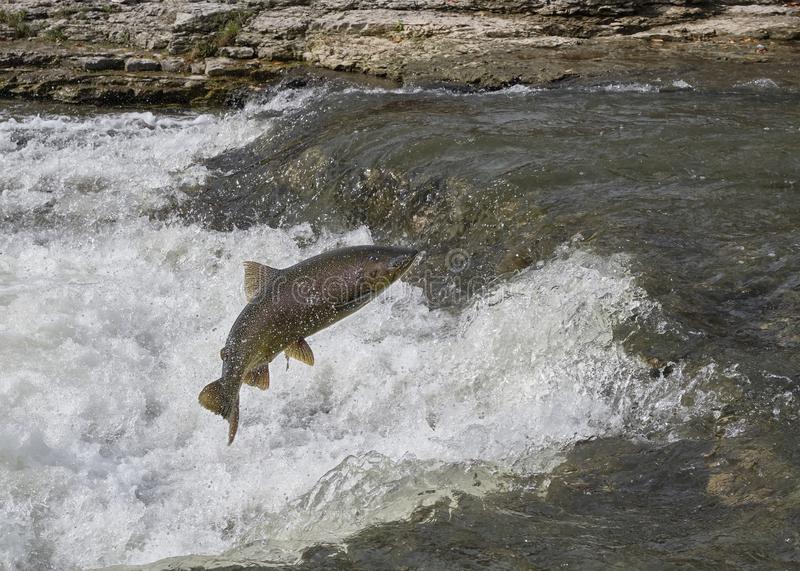
Understanding relationships between organisms and their habitats is important to operators and regulators, as well as being critical to managing species with low population levels. Pacific salmon in the Columbia River system and sage grouse and Lahontan cutthroat trout in the Great Basin are among many examples where understanding the factors limiting the presence or number of individuals in a defined area need to be quantified in a technically sound and legally defensible way.
-

Organisms and Their Habitats
Categories: Estimated reading time: 2 minutes
Understanding relationships between organisms and their habitats is important to operators and regulators, as well as being critical to managing species with low population levels. Pacific salmon in the Columbia River system and sage grouse and Lahontan cutthroat trout in the Great Basin are among many examples where understanding the factors limiting the presence or number of individuals in a defined area need to be quantified in a technically sound an legally defensible way. -
Across the western US drought, wildland fires, cheatgrass, Western juniper, Lahontan cutthroat trout, bull trout, salmon, bald eagles, desert tortoise, and sage grouse all affect where and how natural resource companies operate. Project planning and approvals can be greatly facilitated by application of advanced statistical and spatial models to environmental data. Causal relationships between explanatory variables such as habitat, food, and predators to response variables (species numbers and distributions) are explained by linear regression models.
-
Natural ecosystems are complex and highly variable at multiple size scales. Because of the difficulties of accurately summarizing complexity and variability in an index number, regulators often require a reference area for comparison with a proposed or reclaimed project area. Agreement on a suitable reference area may be a requirement prior to permitting or bond-release decisions for mining and logging operations. It is common for selection of an acceptable reference area to take a long time.